Blog: Posts from March, 2015

Labels
AJAX(112) App Studio(7) Apple(1) Application Builder(245) Application Factory(207) ASP.NET(95) ASP.NET 3.5(45) ASP.NET Code Generator(72) ASP.NET Membership(28) Azure(18) Barcode(2) Barcodes(3) BLOB(18) Business Rules(1) Business Rules/Logic(140) BYOD(13) Caching(2) Calendar(5) Charts(29) Cloud(14) Cloud On Time(2) Cloud On Time for Windows 7(2) Code Generator(54) Collaboration(11) command line(1) Conflict Detection(1) Content Management System(12) COT Tools for Excel(26) CRUD(1) Custom Actions(1) Data Aquarium Framework(122) Data Sheet(9) Data Sources(22) Database Lookups(50) Deployment(22) Designer(177) Device(1) DotNetNuke(12) EASE(20) Email(6) Features(101) Firebird(1) Form Builder(14) Globalization and Localization(6) How To(1) Hypermedia(2) Inline Editing(1) Installation(5) JavaScript(20) Kiosk(1) Low Code(3) Mac(1) Many-To-Many(4) Maps(6) Master/Detail(36) Microservices(4) Mobile(63) Mode Builder(3) Model Builder(3) MySQL(10) Native Apps(5) News(18) OAuth(9) OAuth Scopes(1) OAuth2(13) Offline(20) Offline Apps(4) Offline Sync(5) Oracle(11) PKCE(2) Postgre SQL(1) PostgreSQL(2) PWA(2) QR codes(2) Rapid Application Development(5) Reading Pane(2) Release Notes(183) Reports(48) REST(29) RESTful(29) RESTful Workshop(15) RFID tags(1) SaaS(7) Security(81) SharePoint(12) SPA(6) SQL Anywhere(3) SQL Server(26) SSO(1) Stored Procedure(4) Teamwork(15) Tips and Tricks(87) Tools for Excel(2) Touch UI(93) Transactions(5) Tutorials(183) Universal Windows Platform(3) User Interface(338) Video Tutorial(37) Web 2.0(100) Web App Generator(101) Web Application Generator(607) Web Form Builder(40) Web.Config(9) Workflow(28)
Archive
Blog
Posts from March, 2015
Sunday, March 8, 2015PrintSubscribe
Line Chart Type

The “line” chart type shows a line that plots a value as it changes over the horizontal axis. A typical use case might be plotting a value over time.

To use “line” chart type, add the keyword “line” to any “pivot-” tag, and make sure that it is separated with hyphens (-).

Data Field Tag
OrderDate pivot1-row1-date-line

The chart is using the “date” keyword, which directs the server to attempt several combinations of date groupings. The best fit group is selected and displayed to the user. An equivalent tag combination on OrderDate data field would be “pivot1-row1-year-line pivot1-row2-month”.

Simple line chart using count of orders by order date.

The data for the chart can be seen here.

Data for a simple line chart using count of orders by order date.

Clicking or hovering over a data point will reveal the value.

Clicking on a data point in the line will reveal the value.

When multiple columns or values are specified, more than one line will be drawn with a different color. It is clear that Davolio’s performance in Q1 of 1997 had declined.

Data Field Tag
OrderDate pivot1-row1-year-line pivot1-row2-quarter
EmployeeID pivot1-col1

Multiple values or columns will render as different colored lines in a line chart.

The data displays the multiple columns of data below.

The multiple columns are visible in the data .

By default, lines will be drawn straight. The lines can be curved by specifying the keyword “curve”.

Data Field Tag
OrderDate pivot1-row1-year-line pivot1-row2-quarter pivot1-curve
EmployeeID pivot1-col1

A line chart with "curve" enabled.

The line chart can also be drawn vertically. Specify “vertical” for the orientation property and the chart axes will be flipped.

Data Field Tag
OrderDate pivot1-row1-year-line pivot1-row2-quarter pivot1-orientation:"vertical"
EmployeeID pivot1-col1

A line chart that is drawn vertically.

One can enable zooming and panning on the chart by specifying the “explorer” keyword.

Data Field Tag
OrderDate pivot1-row1-year-line pivot1-row2-quarter pivot1-explorer
EmployeeID pivot1-col1

Using the scroll wheel will change the scale of the vertical axis.

The chart has a very small scale.

The chart has been zoomed in.

Clicking and dragging will pan the chart.

The chart has been panned.

Right-clicking on the chart area will reset the chart. Note that the “explorer” functionality may cause interference with the user scrolling through the page – use only when necessary.

Saturday, March 7, 2015PrintSubscribe
Pie Chart Type

The “pie” chart type is rendered as a circle. Each data point is displayed as a slice out of the circle. This chart type is useful to show the size of values relative to one another. One example may be the number of orders made by each employee – the largest slice of the pie is taken by the employee who made the most orders.

To use “column” chart type, add the keyword “column” to any “pivot-” tag, and make sure that it is separated with hyphens (-).

Data Field Tag
EmployeeID pivot1-row1-pie

A pie chart showing the relative size of orders made by each employee.

The data for the chart can be seen below.
The data showing count of orders by employee.

If the slice is large enough, the percentage value is displayed. Hovering over or clicking on a slice will reveal the data.

The tooltip displaying the value is rendered when hovering over or clicking on a slice of the pie.

If there are too many slices, the chart may become unreadable to the users. Use “topX”, sort the row values, and enable “Other” row to ensure that only the largest X number of slices are displayed, and the rest are collapsed.

Data Field Tag
EmployeeID pivot1-row1-pie-top5-other-sortbyvalue

The pie chart shows top 5 sorted values, with the rest being grouped under "Other".

The sorted top five rows and “Other” row can be seen in the data below.

The data for the pie chart that shows top 5 values, with the rest grouped under "Other" row.

The pie can also be rendered as a 3D pie by using the “pie3d” chart type instead.

Data Field Tag
EmployeeID pivot1-row1-pie3d

The pie chart has been rendered as a 3d pie.

The chart can also be rendered with a hole in the center by specifying the “donut” chart type.

Data Field Tag
EmployeeID pivot1-row1-donut

The pie chart has been rendered as a donut with a hole in the middle.

Saturday, March 7, 2015PrintSubscribe
Geo Chart Type

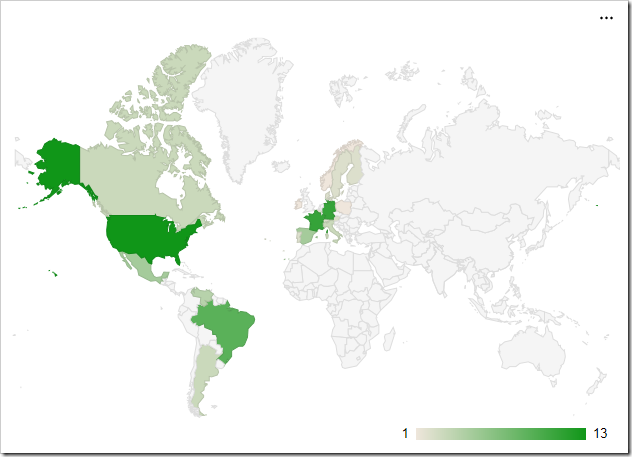
The “geo” chart type will render a map of the Earth. Each value will be a country, region, or city with a number associated with it. Countries with larger numbers will be a darker shade. The scale for the values is shown in the bottom right corner. The example below shows the location of customers by country in the Northwind sample app.

To use “geo” chart type, add the keyword “geo” to any “pivot-” tag, and make sure that it is separated with hyphens (-).

Data Field Tag
Country pivot1-row1-geo

Geo chart showing customers in each country.

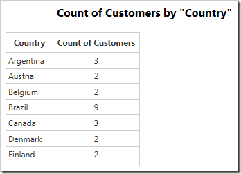
The data for the chart can be seen below.

Data for the geo chart of customers in each country.

Hovering over a data point will reveal the data. An arrow will be rendered on the scale in the bottom right corner.
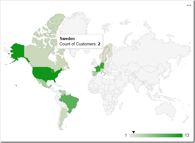
Hovering over a country or region will reveal the value.

The label for each row is attempted to be resolved by Google Maps. Please see the Google Maps Terms of Service for more information on their data policy.

Display Mode

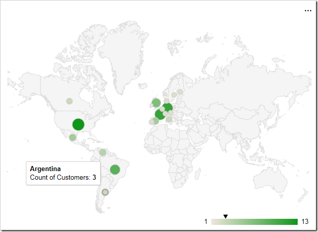
The “displaymode” property determines the rendering of data points on the chart. By default, the mode is determined automatically. When using countries, such as in the example above, it will render using “regions”. One alternative mode is to place markers that are relative to the size of the value by specifying “markers”.

To define the display mode, add the keyword “displaymode”, followed by a colon and the value in quotation marks. This keyword must be the last in the tag.

Data Field Tag
Country pivot1-row1-geo pivot1-displaymode:"markers"

The geo chart also supports displaying values as marker.

Hovering over densely packed data points will magnify the region.

Hovering over dense data points will magnify the area.

Using a display mode of “text” will render the value as a string over the correct location. The size and boldness of the text reflects the size of the value.

The 'text' display mode will render data points as text.

Region

The “region” property allows setting the zoom level of the map. By default, the property is set to “world”, to display the full map. The value can be set to a continent using its 3-digit code, a country with the ISO 3166-1 alpha-2 code, or a state in the United States with the ISO 3166-2:US code. If using a state, the resolution property must be set to “provinces” or “metros”.

The example below is set to zoom into the continent of Europe with code “150”.

Data Field Tag
Country pivot1-row1-geo pivot1-region:"150"

The geo chart is set to only render the region of Europe.

Resolution

The “resolution” property determines the display of data points on the geo chart. By default, it is set to “countries”. The “provinces” value is supported for some country regions and US state regions. The “metros” value is supported for US country region and US state regions only.

Data Field Tag
Region pivot1-row1-geo pivot1-region:"US" pivot1-resolution:"provinces"

The geo chart shows a map of the US and has resolution of 'provinces'.

An example of the “metros” resolution mode can be seen below. The chart uses “markers” display mode.

Data Field Tag
City pivot1-row1-geo pivot1-region:"US" pivot1-displaymode:"markers' pivot1-resolution:"metros"

The geo chart shows a resolution of 'metros' in the United States.

Continue to Column Chart Type