Features

Labels
AJAX(112) App Studio(7) Apple(1) Application Builder(245) Application Factory(207) ASP.NET(95) ASP.NET 3.5(45) ASP.NET Code Generator(72) ASP.NET Membership(28) Azure(18) Barcode(2) Barcodes(3) BLOB(18) Business Rules(1) Business Rules/Logic(140) BYOD(13) Caching(2) Calendar(5) Charts(29) Cloud(14) Cloud On Time(2) Cloud On Time for Windows 7(2) Code Generator(54) Collaboration(11) command line(1) Conflict Detection(1) Content Management System(12) COT Tools for Excel(26) CRUD(1) Custom Actions(1) Data Aquarium Framework(122) Data Sheet(9) Data Sources(22) Database Lookups(50) Deployment(22) Designer(177) Device(1) DotNetNuke(12) EASE(20) Email(6) Features(101) Firebird(1) Form Builder(14) Globalization and Localization(6) How To(1) Hypermedia(2) Inline Editing(1) Installation(5) JavaScript(20) Kiosk(1) Low Code(3) Mac(1) Many-To-Many(4) Maps(6) Master/Detail(36) Microservices(4) Mobile(63) Mode Builder(3) Model Builder(3) MySQL(10) Native Apps(5) News(18) OAuth(8) OAuth Scopes(1) OAuth2(11) Offline(20) Offline Apps(4) Offline Sync(5) Oracle(10) PKCE(2) PostgreSQL(2) PWA(2) QR codes(2) Rapid Application Development(5) Reading Pane(2) Release Notes(180) Reports(48) REST(29) RESTful(29) RESTful Workshop(15) RFID tags(1) SaaS(7) Security(80) SharePoint(12) SPA(6) SQL Anywhere(3) SQL Server(26) SSO(1) Stored Procedure(4) Teamwork(15) Tips and Tricks(87) Tools for Excel(2) Touch UI(93) Transactions(5) Tutorials(183) Universal Windows Platform(3) User Interface(338) Video Tutorial(37) Web 2.0(100) Web App Generator(101) Web Application Generator(607) Web Form Builder(40) Web.Config(9) Workflow(28)
Archive
Blog
Features
Thursday, September 22, 2016PrintSubscribe
Geocoding

Geocoding is the process of capturing an address and converting it to exact latitude and longitude coordinates. Starting with release 8.5.11.0, apps generated with Code On Time now support automatic geocoding of address fields with the proper tags, as well as a Geocode() method available in C# or Visual Basic business rules.
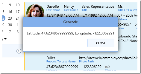
Example of result from Geocode method.

Please make sure to follow Google Maps APIs Terms Of Service. Of note is section 10.5.d, which restricts long-term storage of Content.

Both methods below require addition of a Maps API Identifier. The following examples will use a modified version of the Employees table from the Northwind sample project. Use the following script to add the required columns before creating the project.

ALTER TABLE Employees
ADD Latitude decimal(9, 6) NULL,
    Longitude decimal(9, 6) NULL

If using an existing project, make sure to refresh the application after executing the script. Then, open the model for Employees and check the checkbox next to the three new fields to include them in the Employees controller.

Geocoding with Tags

The easiest way to geocode a set of address fields is to tag the source and destination data fields in the view. If the correct fields are tagged, the values will be geocoded when the user saves a new record or updates an existing record. When updating an existing record, the geocode request will only be sent if at least one of the source fields has been modified, in order to avoid extraneous API requests.

Let’s add the relevant tags to start geocoding employees.

Start the Project Designer. In the Project Explorer, double-click on “Employees / container1 / view1 (Employees, grid1) / createForm1 / c1 – New Employees / Address” data field node.
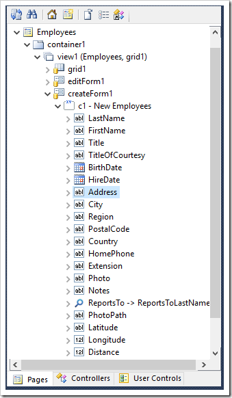
Selecting the Address data field of createForm1 view of Employees controller.

Make the following change:

Property Value
Tags geocode-address

Press OK to save the data field. Use the above procedure to make the changes below:

Data Field Tag
City geocode-city
Region geocode-region
PostalCode geocode-zip
Country geocode-country
Latitude geocode-latitude
Longitude geocode-longitude

On the toolbar, press Browse. When the application opens in the default browser, create a new employee.
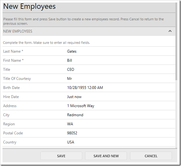
Entering a new employee.

Upon pressing Save, the geocode request will be sent. If a result is returned, the new employee record will have updated Latitude and Longitude fields.
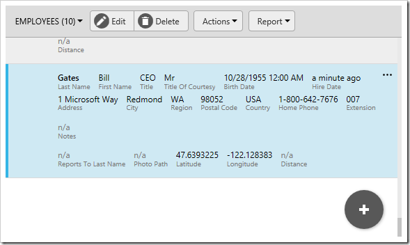
The Latitude and Longitude fields have been updated.

Geocoding in C#/Visual Basic Business Rules

The tag method explained in the previous section is convenient for automatic update of Latitude and Longitude fields. However, if the latitude and longitude need to be used in a calculation, the Geocode() business rule method can be used. Let’s add a business rule that utilizes this method to geocode the employee’s address and show an alert with the resulting latitude and longitude.

In the Project Explorer, switch to the Controllers tab. Right-click on “Employees / Actions / ag4 (ActionBar) – Edit/Delete” and press New Action.

Adding a new action to Employees controller.

Specify the following properties and press OK to save the new action.

Property Value
Command Name Custom
Command Argument ShowLatLong
Header Text Show Lat/Long
When Key Selected Yes

Next, right-click on “Employees / Business Rules” node, and press New Business Rule.

Adding a new business rule to Employees controller.

Configure the rule as following:

Property Value
Type C# / Visual Basic
Command Name Custom
Command Argument ShowLatLong
Phase Execute

Press OK to save the new business rule. Then, press Browse on the toolbar to generate the application, as well as create the relevant business rule file.

When complete, press “Edit Rule” on the action bar to open the file in Visual Studio.

Editing the rule in Visual Studio.

Replace the contents of the file with the following:

C#:

using MyCompany.Data;
using MyCompany.Models;

namespace MyCompany.Rules
{
    public partial class EmployeesBusinessRules : MyCompany.Data.BusinessRules
    {
        
        /// <summary>
        /// This method will execute in any view for an action
        /// with a command name that matches "Custom" and argument that matches "ShowLatLong".
        /// </summary>
        [Rule("r100")]
        public void r100Implementation(EmployeesModel instance)
        {

            decimal latitude;
            decimal longitude;

            // join address parts with "," separator
            string address = string.Join(",", instance.Address, instance.City, 
                instance.Region, instance.PostalCode, instance.Country);

            if (Geocode(address, out latitude, out longitude))
            {
                Result.ShowAlert("Latitude: " + latitude + ", Longitude: " + longitude);
            }
            else
            {
                Result.ShowAlert("Geocode failed to resolve address.");
            }
        }
    }
}

Visual Basic:

Imports MyCompany.Data
Imports MyCompany.Models

Namespace MyCompany.Rules
    
    Partial Public Class EmployeesBusinessRules
        Inherits MyCompany.Data.BusinessRules
        
        ''' <summary>
        ''' This method will execute in any view for an action
        ''' with a command name that matches "Custom" and argument that matches "ShowLatLong".
        ''' </summary>
        <Rule("r100")>  _
        Public Sub r100Implementation(ByVal instance As EmployeesModel)
            Dim latitude As Decimal
            Dim longitude As Decimal

            ' join address parts with "," separator
            Dim address = String.Join(",", instance.Address, instance.City,
                            instance.Region, instance.PostalCode, instance.Country)

            If (Geocode(address, latitude, longitude)) Then
                Result.ShowAlert("Latitude: " & latitude & ", Longitude: " & longitude)
            Else
                Result.ShowAlert("Geocode failed to resolve address.")
            End If
        End Sub
    End Class
End Namespace

Switch back to the application running in your default browser, and navigate to the Employees page. Ctrl+click on a row to highlight the row. On the toolbar, press  “Show Lat/Long”.

Activating the "Show Lat/Long" custom action.

A message box will be displayed with the employee’s latitude and longitude.

The popup shows the returned latitude and longitude.

Thursday, September 22, 2016PrintSubscribe
Adding a Google Maps API Key

An API key must be added to the project to use any features that depend on the Google Maps API, such as Maps presentation style, Geocode feature, or CalculateDistance() business rule method. The Google Maps API Key can be acquired here. Make sure to log into your Google account, and press the “GET A KEY” button to get started.

The button to acquire a Google Maps API key.

Once a key has been acquired, start the app generator. Click on the project name, and press Settings. Then, select Features page of the Project Wizard.

Navigating to the Features page of the Project Wizard.

Switch to the Touch UI section. If you have an API key, under “key=” plus the key in the “Google Maps API Identifier” box. If you have a client ID, enter “client=” plus the client ID in the box.

Entering the Maps API Identifier.

Press Next, and proceed to generate the application. The key will be embedded in “web.config” file of the generated application.

The API key can be accessed from any custom code or code business rules via the “ApplicationServices.MapsApiIdentifier” property. It can also be accessed from JavaScript business rules via the “__settings.mapApiIdentifier” property.

It is highly recommended to restrict access to your key to specific websites, IP address, or apps from the Google Developer Console.

Wednesday, September 21, 2016PrintSubscribe
Speeding Up Quick Find

The Quick Find feature is available by default in all data views of an application. This feature allows searching every field available in the grid all at once.

Quick Find can be triggered by pressing on the Search icon in the top right corner of the data view, or by typing when a full screen data view is in focus.

Activating the Quick Find by pressing the Search icon.

Type in a value and hit “Enter” key on the keyboard to begin the search.

Typing in a value to the Quick Find input box.

When the search is complete, the search query will be displayed in the view header and the results will be displayed in the grid.

When Quick Find is triggered, the query is displayed in the header and the results below.

Each word separated by a space will search for results containing both words. Words separated by commas will search for results containing either word. Results can be negated by adding a dash (-) before the word. Exact phrases can be wrapped in “double quotes”. The example below executes the following search:

“Camembert Pierrot”, tea –grandma

The search returns records that contain the phrase “Camembert Pierrot” exactly, or records that contain “tea” and do not contain “grandma”.

Two results are returned.

However, while using Quick Find is perfect for small to medium size tables or views with a small number of columns, it can cause a substantial performance hit when the grid contains many different columns, and there is a large number of records in the table. Each column must be searched for that particular combination of keywords. While it is still possible to use Advanced Search in order to query specific columns, it does not beat the convenience offered by Quick Find.

In order to avoid the performance hit caused by searching every column, it is possible to reduce the Quick Find search scope to an inclusive or exclusive set of fields in the grid.

Excluding Specific Fields Using “$quickfinddisabled”

The quickest way to add performance is to add the tag “$quickfinddisabled” to the Search Options property of the data field. This will exclude the column from the search.

Let’s remove the QuantityPerUnit data field from the Quick Find query of Products page in the sample Northwind project.

Start the Project Designer. Switch to the Project Explorer tab. Double-click on “Products / Views / grid1 / QuantityPerUnit” data field.

Editing the QuantityPerUnit data field of grid1 View of Products controller.

Make the following change:

Property Value
Search Options $quickfinddisabled

Press OK to save. On the toolbar, press Browse.

Navigate to the Products page and execute a Quick Find search. Notice that Quantity Per Unit will now be ignored when using Quick Find.

Quick Find will no longer use Quantity Per Unit field in the filter.

Including Specific Fields Using “$quickfind”

It is also possible to only include specific fields by using the “$quickfind” tag. Let’s reduce the Quick Find scope on Products page to only ProductName and CategoryName fields.

Switch back to the Project Designer. Make sure to clear any “$quickfinddisabled” tags, as these are exclusive.

Double-click on “Products / Views / grid1 / ProductName” data field node.

Editing ProductName data field in grid1 view of Products controller.

Make the following change:

Property Value
Search Options $quickfind

Press OK to save the data field.

The next data field to modify is CategoryName. However, this data field is being used as the Alias for CategoryID data field, and has not been added to grid1 view. We will need to add CategoryName data field to grid1 in order to modify the behavior. This data field will not be rendered twice.

Drag the field “Products / Fields / CategoryName” onto “Products / Views / grid1” view to instantiate a data field for CategoryName field.

Dragging CategoryName field onto grid1 view.  The CategoryName data field has been added to grid1.

Next, change the configuration for CategoryName data field.

Property Value
Search Options $quickfind

Press OK to save. On the toolbar, press Browse. Navigate to Products page and search for “tea”. Notice that Supplier Company Name is not searched - results do not include those with Supplier of “Grandma Kelly’s Homestead”.

The Quick Find query has excluded all fields that were not tagged with "$quickfind".

Continue to Smart Dates